1
Introduction
The Joint Statement accompanying the Consolidated Appropriations Act, 2022, which was enacted into law, included the following:
Robotically Assembled Earth Science Platform.—NASA is encouraged to support, in partnership with industry, the development and deployment of capabilities using NASA-supported robotic assembly and on-orbit structure manufacturing technologies to enable operation of multiple modular Earth remote sensing instruments.
Committee reports accompanying FY 2023 appropriations bills from both the U.S. House of Representatives and the U.S. Senate contain language directing NASA to study the feasibility and practicality of partnering with industry to develop a space-based platform using multiple modular Earth remote sensing instruments to conduct Earth science observations.1 To assist in their preparation of the requested analysis, NASA requested the National Academies’ CESAS conduct a short study that would assess the potential use of a proposed multi-user, robot-tended, uncrewed commercial space platform as a potential host for a large number of Earth remote sensing instruments. NASA requested that the study:
- Consider a notional platform in a Sun-synchronous orbit (nominally 600–800 km) capable of hosting 20 or more instruments; and
___________________
1 “The Use of On-Orbit Assembly Platforms.—The Committee on Appropriations notes interest from industry in partnering with NASA, to support the development and demonstration of a prototype on-orbit robotically assembled Earth Science Platform designed to address critical gaps in NASA’s climate, weather, and ecosystem monitoring. Such a platform could demonstrate a space-based capability for autonomous and simultaneous operation of multiple modular Earth remote sensing instruments that utilizes robotic assembly and on orbit structure manufacturing technologies derived from the On-Orbit Servicing, Assembly, and Manufacturing 2 (OSAM-2) SBIR (Small Business Innovation Research) Phase III effort. Within 180 days of enactment of this act, NASA shall submit to the Committee and make public an analysis of whether such a mission is feasible and fits within NASA’s plans for Earth Science or for commercially developed LEO platforms funded in Space Operations” (U.S. Senate, “Explanatory Statement for Commerce, Justice, Science, and Related Agencies Appropriations Bill, 2023,” https://www.appropriations.senate.gov/download/cjsfy23rpt, p. 149).
Also, “Robotically Assembled Earth Science Platform.—The Committee directs NASA to provide a report, not later than 180 days after enactment of this Act, on the feasibility, necessity and relative priority of partnering with industry to develop and demonstrate a prototype on-orbit robotically assembled Earth Science Platform that utilizes robotic assembly and on-orbit structure manufacturing technologies derived from the OSAM–2 SBIR Phase III effort. The report should outline any future funding needs associated with this potential demonstration” (“Report of the Committee on Appropriations to accompany the Commerce, Justice, Science, and Related Agencies Appropriations Bill, 2023,” https://docs.house.gov/meetings/AP/AP00/20220628/114966/HMKP-117-AP00-20220628-SD004.pdf, p. 120). Note: On December 29, 2022, President Biden signed the Consolidated Appropriations Act, 2023 (H.R. 2617) into law.
- Consider the impacts on NASA’s ability to achieve Recommendation 3.2 from the 2017 decadal survey2 regarding the recommended additional observations classified within the Designated Observables, Earth System Explorer, Incubation, and Earth Venture elements, as described in Table 3.3, Observing System Priorities.
In its request (see Appendix A, Statement of Task), NASA further specified that potential impacts on the existing Program of Record were not within the scope of the committee’s assessment; however, the committee could comment in general terms on considerations for the use of the notional platform versus existing plans to accomplish survey priorities. In addition, the committee was invited to comment on how the use of the notional platform would compare with the deployment of its instrument complement via multiple free-flyers in different orbits, the impacts of possible consolidation of a platform at a single nodal crossing time, and how well any single orbit could satisfy the survey priorities.
At the request of the committee, NASA also provided the following “working assumptions” to scope the assessment:
- Orbit: Non-human-tended SSO at 600–800 km in altitude with inclination around 98°.
- Platform size: Single platform capable of accommodating 20 or more instruments.
- Instrument parameters: Volume of approximately 1 m3 and mass of 50–200 kg each, but can handle deviations from these approximations based on the instrument specifics.
- Launch time frame: Calendar year 2025 to 2027.
- Power: The platform will be capable of providing the power (average and peak) necessary to accommodate 20 or more instruments.
- Communications: The platform will be capable of accumulating housekeeping and science data stored onboard and downloaded at least every day.
- Platform lifetime: 10 years.
- Other variables: Pointing stability/jitter, pointing knowledge, thermal interfaces, and data rate/volume sufficient to accommodate 20 or more instruments.
CHARACTERISTICS OF THE NOTIONAL PLATFORM
Studies of the dynamic Earth system and its coupled processes often benefit—and sometimes require—coordinated, near-simultaneous measurements from the vantage point of space. Multiinstrument platforms and/or constellations of spacecraft flying in a particular orbit, and potentially in close proximity, are examples of how to achieve such measurements. NASA’s Earth Observing System (EOS) flagship Terra (five instruments), Aqua (six instruments), and Aura (four instruments), and the European Space Agency’s (ESA’s) Envisat (10 instruments), are examples of the former, while the spacecraft that comprise the “A-Train”3 are an example of the latter.
The ISS has also served as a host platform for a variety of Earth observing instruments allowing, for example, the study of fundamental characteristics of terrestrial ecosystems.4 As of December 2022,
___________________
2 NASEM, 2018, Thriving on Our Changing Planet.
3 NASA, 2012, “The Afternoon Constellation—A-Train,” https://atrain.nasa.gov.
4 J.B. Fisher, E.N. Stavros, R. Pavlick, S.J. Hook, A. Eldering, R. Dubayah, T. Matsunaga, S. Serbin, and D. Schimel, 2019, “The International Space Station as a Key Platform to Synergize Observations of Fundamental Ecosystem Properties,” presentation to the Terrestrial Ecology Science Team Meeting, September 23, https://cce.nasa.gov/meeting_te_2019/index.html.
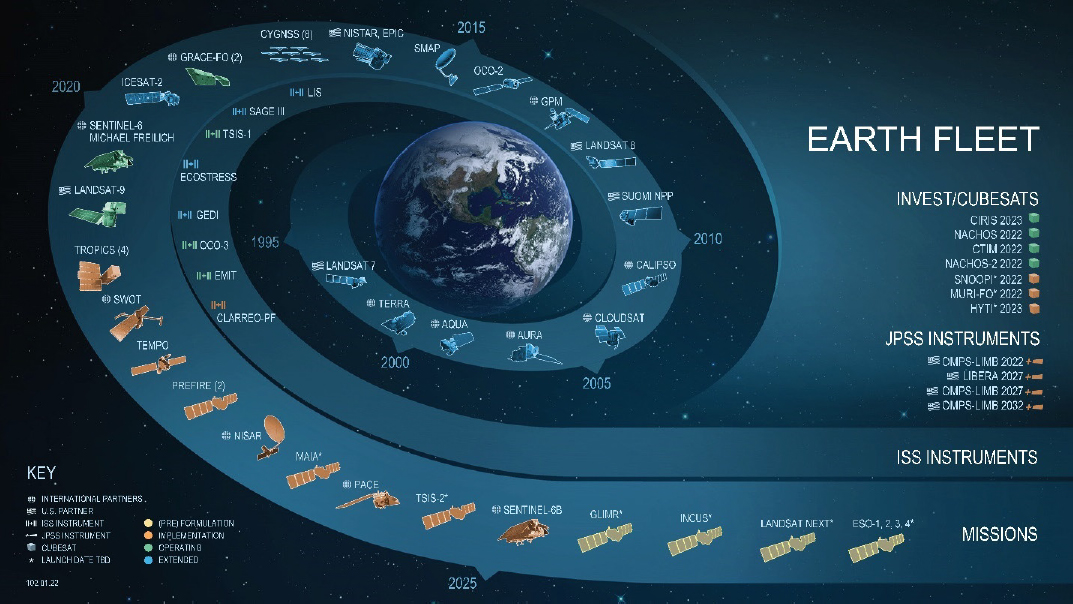
NOTE: This figure has not been updated to reflect the successful launches of the SWOT mission (December 15, 2022) and TEMPO (April 7, 2023).
SOURCE: NASA, https://science.nasa.gov/science-red/s3fs-public/atoms/files/esd-fleet-swoosh-120122.pdf.
ecosystem-related missions hosted on the ISS included ECOSTRESS (Ecosystem Spaceborne Thermal Radiometer Experiment on Space Station), GEDI5 (Global Ecosystem Dynamics Investigation), OCO-3 (Orbiting Carbon Observatory 3), and the recently installed EMIT (Earth Surface Mineral Dust Source Investigation). NASA’s extensive fleet of NASA Earth observation instruments and missions are depicted in Figure 1-1.
The notional platform that is the subject of this short study is both related to, and different from, the platforms NASA (and NOAA and USGS) have historically used for Earth observations:
- A key and novel attribute of the platform would be its use of robotic servicing to execute instrument repairs and swaps in routine fashion at some cadence.
- In addition to being robotically tended, the platform could potentially make use of novel In-Space Servicing, Assembly, and Manufacturing (ISAM) techniques.6
___________________
5 NASA announced in February 2023 that GEDI would be moved in March to a storage location on the ISS where it will remain offline for about 18 months while a Department of Defense technology payload completes its mission. NASA plans to return to GEDI to its original location and resume operations on the station in 2024. Operation of the GEDI lidar on ISS has not been without its challenges. See S.M. Sidik, 2022, “Scientists Fight to Keep Lidar on the Space Station,” Eos, April 6, https://eos.org/articles/scientists-fight-to-keep-lidar-on-the-space-station.
6 See NASA, 2022, “NASA’s Exploration & In-Space Services,” https://nexis.gsfc.nasa.gov/isam/index.html; and NASA, 2022, “National In-Space Servicing, Assembly, and Manufacturing Implementation Plan,” https://www.whitehouse.gov/wp-content/uploads/2022/12/NATIONAL-ISAM-IMPLEMENTATION-PLAN.pdf. See also D. Arney, R. Sutherland, J. Mulvaney, D. Steinkoenig, C. Stockdale, and M. Farley, 2021, “On-Orbit Servicing, Assembly, and Manufacturing (OSAM) State of Play, 2021 Edition,” October 27, https://ntrs.nasa.gov/api/citations/20210022660/downloads/osam_state_of_play%20(1).pdf.
- The baseline concept calls for hosting some 20 or more instruments, far in excess of the number of instruments on NASA “facility-class” flagship EOS missions. Hosting such a large number of instruments could pose both engineering and accommodation challenges.
- NASA spacecraft are typically designed to operate for 2–5 years, with longer design lives requiring additional redundancy and other steps that increase cost. By comparison, the notional platform would require a much longer design life if it were to serve as a persistent platform where instruments would operate until being swapped out for a replacement or a new instrument. The working assumption given to the committee was a lifetime of 10 years.
- Although the notional platform would be commercially developed, its viability would appear to depend on having the federal government (NASA and/or NOAA) as an anchor tenant both for platform establishment and continuity.
The notional platform is envisioned for launch in 2025–2027. Even if the platform were in place in this time frame, it is highly unlikely that the 20 or more science-ready instruments would be available given existing federal program constraints. While outside of this study’s scope, it should be noted that filling the platform is therefore likely to require multiple launches over a multi-year period—an issue that should be addressed in analyzing the “business case” for the platform. Engineering and accommodation issues and issues related to replenishment and servicing of the notional platform are also outside scope of this study.
For the most part, apart from orbital characteristics, the committee does not comment on the compatibility of the notional platform as a host for various instrument combinations.7 Topics either out of scope or requiring expertise beyond that of this committee include an analysis of how the notional platform in SSO with its 20 or more instruments would compare to alternative architectures utilizing smaller platforms hosting multiple instruments and tailored orbits, or how the notional platform could be integrated into existing Earth observation architectures. A future study might also consider architectures that might employ more than one robot-tended platform, each of which could be tailored to accommodate measurement needs.
Asked to provide an overview of the task given to CESAS, Bhavya Lal, NASA Associate Administrator for Technology, Policy and Strategy and Acting Chief Technologist, remarked:
For the particular case of a large Earth observation platform enabled by ISAM, many of the most important questions to address by the committee discussion today is whether and what types of observations are enabled by the approach, and if that’s what the community needs.8
CESAS members agreed strongly with this view, which was reflected in committee deliberations and informed the committee’s brief analysis described below.
SUN-SYNCHRONOUS AND OTHER ORBITS FOR EARTH OBSERVATIONS FROM SPACE
NASA, NOAA, USGS, and U.S. international partners conduct Earth science observations from space utilizing instruments on platforms that are placed in a variety of orbits according to measurement needs.9 For science objectives involving regular high temporal frequency observations of dynamic processes, one
___________________
7 Instruments hosted on the notional platform would need to be compatible with the platform’s volume, mass, telemetry, and power capabilities, as well as its thermal and vibration environment and its positioning accuracy, pointing accuracy, and stability. Other considerations include minimization of field-of-view incursions or other interferences (e.g., radio frequency) among the assumed 20 or more instruments, and the capability to support various on-orbit calibration approaches, which could also require periodic maneuvers of the platform.
8 B. Lal, “Opening Remarks on CESAS Task.”
9 NASA, 2009, “Catalog of Earth Satellite Orbits,” NASA Earth Observatory, September 4, https://earthobservatory.nasa.gov/features/OrbitsCatalog.
can either employ constellations of spacecraft in low Earth orbit (LEO) or deploy instruments on a platform in geostationary orbit (35,786 km).10 A multi-instrumented platform and/or constellations of spacecraft flying in formation may be used to study processes that require coordinated measurements from multiple types of sensors. There are trade-offs among all these options, many driven by the required temporal and spatial resolution; however, for this report, it is the constraints imposed by use of a single SSO platform with a particular orbital altitude, inclination, and local equator crossing time that are noteworthy.
Platforms in LEO comprise a large fraction of the U.S. Earth science fleet with many launched into high-inclination11 (near-polar) SSOs12 at an altitude of 600–800 km. A satellite in SSO passes over a particular location at the same local time. This allows consistent scientific observations with the angle between the Sun and Earth’s surface remaining relatively constant (Figure 1-2). A low-inclination orbit may be desirable for monitoring regions closer to the equator (e.g., the Tropical Rainfall Measurement Mission [TRMM] was launched into an orbit with an inclination of 35°).
NASA also makes Earth observations from the ISS, whose relatively low altitude and low inclination are the result of launch constraints and a number of other considerations. The ISS orbits at an altitude of approximately 400 km with an inclination of 51.6°; its precessing ground track provides sampling opportunities across the diurnal cycle.13 The low altitude of the ISS facilitates high spatial resolution measurements. However, it is not in a Sun-synchronous orbit, which complicates image analysis and sensor calibration. On the other hand, the ISS is human tended, making instrument repairs or swaps possible, and it also has large power reserves that can be used to support active remote sensing.
Earth science observations from SSO are tailored to particular applications and, as illustrated in the examples described below, a single platform with a particular SSO is not suitable for all applications.
One particularly important orbit is the SSO used by NASA’s “A-Train” constellation, which allows for near-simultaneous coordinated measurements (see Figure 1-3). Platforms in this orbit have an inclination of 98.14° and cross the equator each day at around 1:30 pm solar time. However, earlier crossing times are associated with improved likelihood of cloud-free imaging. Thus, while Landsat-9, the most recent in the Landsat series, is also in Sun-synchronous polar orbit, its orbit crosses the equator at
___________________
10 NOAA operates the Geostationary Operational Environmental Satellites (GOES), which carry instruments that provide images of weather patterns, hurricanes, and severe storms as frequently as every 30 seconds. The latest generation of the GOES series also includes an operational lightning mapper (developing severe storms often exhibit a significant increase in total lightning activity).
11 Orbital inclination is the angle between the plane of an orbit and the equator. An orbital inclination of 0° is directly above the equator, 90° crosses right above the pole, and 180° orbits above the equator in the opposite direction of Earth’s spin. Op. cit., fn. 10.
12 A satellite in an SSO would typically be in a near-circular orbit of between 600 and 800 km with an inclination of approximately 98°. A low-inclination orbit would give better coverage of equatorial regions of the Earth (e.g., the TRMM had an inclination of 35°). Op. cit., fn. 10.
13 Regarding the relative advantages of the SSO and the ISS orbits: “The main advantage of an inclined orbit is that a limited set of latitudes is sampled at different local times of day, including during nighttime hours.… For an Earth observing instrument to take full advantage of this it would need to have nightside observing capabilities, i.e., not relying on reflected solar radiation. Even for instruments that do rely on the Sun, there is a clear benefit of discarding some observed scenes in favor of sampling the atmosphere over source regions that include emissions with a diurnal cycle. The main disadvantage of an inclined orbit is the converse argument for its advantage: it samples a limited range of latitudes at different times of day, so the resulting data, especially related to atmospheric composition, are difficult to interpret without a time-dependent computational model that includes a description of emissions and atmospheric chemistry and transport. However, this is also true when interpreting data collected by instruments in Sun-synchronous orbits.” (P.I. Palmer, A.J.P. Woodwark, D.P. Finch, et al., 2022, “Role of Space Station Instruments for Improving Tropical Carbon Flux Estimates Using Atmospheric Data,” npj Microgravity 8:51).
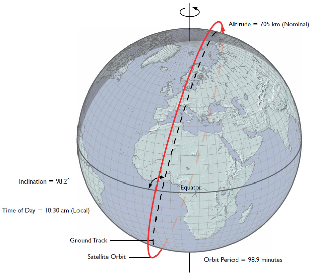
NOTE: SSOs are specified in terms of the time of day they cross the equator on the sunlit side of the orbit (10:30 am local time in this Terra example).
SOURCE: NASA, Earth Observing System Project Science Office, https://eospso.nasa.gov/files/ocp/pdf/Page_339_new.pdf.
approximately 10:00 am solar time. This orbit also maintains heritage with the other currently operating Landsats.
The requirements for the ESAS 2017 decadal survey’s14 recommended Surface Biology and Geology (SBG) mission15 also illustrate the need for tailored orbits. Following detailed architecture and trade studies, SBG is proposed to be implemented with its key instruments—the Visible and Short-Wave Infrared (VSWIR)16 sensor and the thermal infrared (TIR)17 sensor—hosted on separate platforms in SSOs, with crossing and revisit times optimized for their different applications (TIR is planned to be hosted on a free-flyer). Box 1-1 provides another illustration of how understanding of the Earth system may require multiple sensors in different orbital configurations.
___________________
14 NASEM, 2018, Thriving on Our Changing Planet.
15 D.S. Schimel and B. Poulter, 2022, “The Earth in Living Color—NASA’s Surface Biology and Geology Designated Observable,” 2022 IEEE Aerospace Conference (AERO), https://doi.org/10.1109/AERO53065.2022.9843640, pp. 1–6. See also E.N. Stavros, J. Chrone, K. Cawse-Nicholson, et al., 2022, “The Surface Biology and Geology Architecture Study Science and Applications Traceability Matrix (SATM),” Zenodo, https://doi.org/10.5281/zenodo.6325668, and NASA, 2022, “Science and Applications Traceability Matrix—Surface Biology and Geology,” https://sbg.jpl.nasa.gov/satm.
16 R.O. Green, et al., 2022, “Surface Biology and Geology (SBG) Visible to Short Wavelength Infrared (VSWIR) Wide Swath Instrument Concept,” pp. 1–10 in 2022 IEEE Aerospace Conference (AERO), https://doi.org/10.1109/AERO53065.2022.9843676.
17 R.R. Basilio, S.J. Hook, S. Zoffoli, and M.F. Buongiorno, 2022, “Surface Biology and Geology (SBG) Thermal Infrared (TIR) Free-Flyer Concept,” pp. 01–09 in 2022 IEEE Aerospace Conference (AERO), https://doi.org/10.1109/AERO53065.2022.9843292.
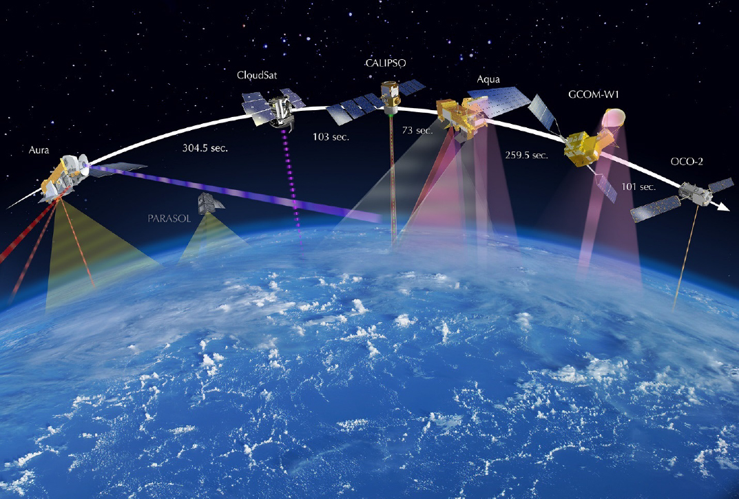
NOTES: With some platforms exiting the A-Train, the constellation currently consists of the OCO-2; the NASA-JAXA GCOM-W1; and Aqua. Active instruments aboard CALIPSO and CloudSat are indicated with dashed lines. This illustration color-codes instrument swaths—the area of Earth’s surface, or the surface of its atmosphere, over which data are collected—based on observed wavelength ranges. Microwaves (observed by both AMSR instruments, AMSU-A, CPR, MLS) are represented as red-purple to deep purple colors; yellow represents solar wavelengths (OMI, OCO-2); gray represents solar and infrared wavelengths (MODIS, CERES); and red represents other infrared wavelengths (IIR, AIRS, TES, HIRDLS). Additional details on these instruments are available at https://atrain.nasa.gov. Acronyms are defined in Appendix B.
SOURCE: NASA. “A-Train Historical Graphics.” https://atrain.nasa.gov/images/A-Train_w-Time2017_web.jpg.
NASA’s Earth Observing System flagship missions, Terra, Aqua, and Aura were placed in SSO, but with differing local mean time equator crossing times to optimize operations of key sensors monitoring Earth’s surface, oceans, and atmosphere (Terra, 10:30 am; Aqua, 1:30 pm; and Aura, 1:45 pm), which allows its Advanced Spaceborne Thermal Emission and Reflection Radiometer (ASTER) and MODIS instruments to collect a consistent historical record of land data products. Weather satellites also operate in SSO, with the Department of Defense (Space Force), the European Organisation for the Exploitation of Meteorological Satellites (EUMETSAT), and the Department of Commerce (NOAA) utilizing morning, mid-morning, and afternoon orbits to provide imagery and data for numerical weather prediction models.
The NASA-Indian Space Research Organization (ISRO) Synthetic Aperture Radar (SAR) (NISAR) mission, scheduled for launch in 2024, will measure Earth’s changing ecosystems, dynamic surfaces, and ice masses, providing information about biomass, natural hazards, sea level rise, and groundwater, and will support numerous other applications.18 NISAR will observe Earth’s land and ice-covered surfaces
___________________
18 NASA, 2022, “Home—NASA-ISRO SAR Mission (NISAR),” https://nisar.jpl.nasa.gov.
globally with 12-day regularity for ascending and descending passes, sampling Earth on average every 6 days for a baseline 3-year mission. Distortions of the SAR data from ionospheric variations are a key concern as they map directly into distortions in the ground displacement measurement. A dawn-dusk orbit minimizes this effect since the maximum ionosphere distortions are at noon. NISAR will be launched into Sun-synchronous dawn-dusk orbit with crossing times of 6:00 am and 6:00 pm.
A number of key Earth observations are not suitable for any platform placed in SSO. The Surface Water and Ocean Topography (SWOT) mission, launched in December 2022, carries a radar altimeter capable of deriving two-dimensional images of surface water height, with a vertical accuracy of about 1 cm averaged over 1 km2 across a 120 km swath. SWOT was not launched in an SSO in order to avoid solar tide aliasing that would limit the capabilities of the altimeter.19
Another example of the use of non-SSO is seen in the Global Precipitation Measurement (GPM) mission. GPM’s Core Observatory satellite operates in LEO, carrying two instruments for measuring Earth’s precipitation and serving as a calibration standard for other members of the GPM satellite constellation. The GPM Core Observatory does not operate in SSO; it orbits Earth at an inclination of 65°, which enables it to cut across the orbits of other microwave radiometers and sample the latitudes where nearly all precipitation occurs.20 Measurements of Earth’s gravity field are also not well suited for implementation on the large platforms for a number of reasons: the measurements require two spacecraft and, even if a trailing free-flyer were added, the altitude is higher than desired.21
___________________
19 A comprehensive review of Earth observations for hydrological applications is available in M.F. McCabe, M. Rodell, D.E. Alsdorf, et al., 2017, “The Future of Earth Observation in Hydrology,” Hydrology and Earth System Sciences 21(7):3879–3914, https://doi.org/10.5194/hess-21-3879-2017.
20 NASA, 2018, “Missions | NASA Global Precipitation Measurement Mission,” https://gpm.nasa.gov/missions.
21 The Gravity Recovery and Climate Experiment (GRACE), its successor, GRACE-Follow-on (GRACE FO), and the planned Mass Change mission have been, or will be, implemented on twin satellites flying in tandem in a non-Sun-synchronous orbit. These missions rely on highly precise measurements of the changes in distance between the tandem satellites—along with a complex analysis—to recover the time and spatial variation of Earth’s gravity
NASA is also a user of platforms in geostationary orbit. For example, it has selected multiple Earth Venture Instrument investigations that require geostationary orbits. Examples include Tropospheric Emissions: Monitoring of Pollutants (TEMPO), Geostationary Littoral Imaging and Monitoring Radiometer (GLIMR). It also selected a stand-alone mission, the Geostationary CARBon cycle observatory (GeoCarb), which was recently terminated.22 In that case, the choice of a geostationary orbit was necessitated by the mission’s primary objective of understanding the global carbon cycle and associated monitoring requirements for key greenhouse gases (GHGs).23
NASA’S REQUEST
As already noted, NASA’s specific request to CESAS is to consider the notional large platform in SSO and assess its impacts on NASA’s ability to achieve Recommendation 3.224 from ESAS 2017
___________________
field. The notional platform, as one part of a tandem pair, is not suited for these measurements because Sun-synchronous orbits are higher than the GRACE/GRACE-FO orbits (by 100–400 km). Increases in altitude decreases sensitivity of the gravity field.
- The Sun-synchronous orbit will not be as close to a 90° inclination as a free-flying pair. This would reduce considerably coverage over the Arctic Ocean and Antarctica.
- The notional platform would be in an exact repeat orbit, probably with a repeat period somewhere between 10 and 20 days, resulting in considerable geographical gaps of gravity measurements. The GRACE and GRACE-FO pairs are not in a repeat orbit, but in a drifting orbit where they tend to cover every 300 km × 300 km area of the Earth at least once. That allows quasi-global coverage every 30 days. (When the pairs get into a repeat orbit resonance, they are maneuvered out of it—there have been a few months where they were transitioning through a 4–5 day repeat and the gravity fields are noticeably degraded.)
The committee also notes that the stringent pointing requirements required for the ranging measurements may not be possible on the notional platform, which is likely to have large trusses.
22 NASA, 2022, “NASA to Cancel GeoCarb Mission, Expands Greenhouse Gas Portfolio,” press release, https://www.nasa.gov/press-release/nasa-to-cancel-geocarb-mission-expands-greenhouse-gas-portfolio.
23 NASA is attempting to salvage the science supporting the targeted applications from GeoCarb with existing assets such as the Orbiting Carbon Observatory satellites (OCO-2 in SSO and OCO-3 on the ISS) and the recently launched Earth Venture, EMIT. A future Earth System Explorer is also being prioritized for GHG observations. However, the OCO instruments and EMIT are in low Earth orbit and cannot provide the high temporal sampling enabled by observations from GEO. “The abundance and distribution of carbon-bearing gases in the atmosphere are determined by both the exchange of carbon between Earth’s land areas, oceans and the atmosphere, and their transport by prevailing winds. These exchanges are best understood by making frequent, densely spaced observations. While satellites in Sun-synchronous, polar low-Earth orbits like OCO-2 provide global coverage, they have long revisit times, large gaps in coverage, and always look at the landscape at the same time of day. Because weather affects ecosystems on timescales of days to weeks, polar orbiting satellites may miss these changes and how they interconnect with the activities of living organisms—information that is crucial to developing better models of Earth system processes.” See NASA, 2023, “GeoCarb: A New View of Carbon Over the Americas,” https://www.nasa.gov/feature/jpl/geocarb-a-new-view-of-carbon-over-the-americas.
24 Recommendation 3.2: NASA should implement a set of space-based observation capabilities based on this report’s proposed program (which was designed to be affordable, comprehensive, robust, and balanced) by implementing its portion of the Program of Record and adding observations described in Table 3.3, “Observing System Priorities.” The implemented program should be guided by the budgetary considerations and decision rules contained in this report and accomplished through five distinct program elements:
- Program of Record. The series of existing or previously planned observations, which must be completed as planned. Execution of the ESAS 2017 recommendation requires that the total cost to NASA of the Program of Record flight missions from FY 2018 through FY 2027—October 1, 2017, through September 30, 2027—be capped at $3.6 billion.
regarding the recommended observations classified within the Designated Observables (DOs), Earth System Explorer, Incubation, and Earth Venture elements, as described in Table 3.3, “Observing System Priorities.” That table is reproduced here in Table 1-1, with the Designated Observables shown in light green, the candidates for Earth System Explorers or Incubation shown in light gray, and other Targeted Observables,25 not allocated by the survey to a flight program element, shown in light blue.
At the October 17–18, 2022, committee meeting, NASA officials agreed with the committee that it is too late to consider implementation of the DOs on the notional platform. The missions associated with the DOs have already been studied for several years and they were approaching evaluation for readiness to enter Phase A development.26 Therefore, NASA gave CESAS the option of focusing its evaluation on the Earth System Explorers, Earth Venture, and Incubation. While exercising this option, the committee does comment on the suitability of the large platform as a host for instruments that could address the DOs, illustrating the potential of the platform to serve as a host for follow-ons that might continue or expand on these high-priority observations (see Table 4-1). However, except for “Radiance intercalibration,” which is included for illustrative purposes, the committee has chosen to exclude from its analysis the Targeted Observables that ESAS 2017 could not allocate to a flight program element because of budget constraints. Finally, the committee cannot predict selections that will be made as part of NASA’s Earth Venture;27 therefore, its analysis of the suitability of the large platform as a host for instruments in this line is generic in nature.
___________________
- Designated. A program element for ESAS-designated, cost-capped, medium- and large-size missions to address observables essential to the overall program, directed or competed at the discretion of NASA.
- Earth System Explorer. A new program element involving competitive opportunities for cost-capped, medium-size instruments and missions serving specified ESAS-priority observations.
- Incubation. A new program element, focused on investment for priority observation capabilities needing advancement prior to cost-effective implementation, including an innovation fund to respond to emerging needs.
- Earth Venture. Earth Venture program element, as recommended in ESAS 2007, with the addition of a new Venture-continuity component to provide opportunity for low-cost sustained observations.
(NASEM, 2018, Thriving on Our Changing Planet, p. 11)
25 Targeted Observables were identified by the decadal survey steering committee as observations needed in the coming decade beyond those of NASA and the International Programs of Record.
26 The AOS, MC, and SBG Designated Observables underwent their Mission Concept Reviews in May and June 2022. Subsequently, Atmosphere Observing System (AOS Storm and AOS Sky), Surface Biology and Geology (SBG), and Mass Change (MC) passed KDP A and are now in Formulation. As of March 2023, NASA planned to have SDC remain in extended study phase to take advantage of NISAR mission lessons learned. (From Karen St. Germain, briefing to the Committee on Earth Science and Applications from Space, March 29, 2023, https://www.nationalacademies.org/event/03-28-2023/committee-on-earth-sciences-and-applications-from-space-space-science-week-spring-meeting-2023.)
27 Earth Venture (EV) missions currently consist of principal investigator (PI)-led suborbital and orbital missions, instruments developed for spaceflight missions of opportunity, and CubeSats. All EV-class missions are cost and schedule constrained and openly competed. The EV class of missions were created to “conduct low-cost Earth science research and application missions to demonstrate innovative ideas and higher-risk technologies and provide training for future leaders of space-based observations for Earth science applications” (NASEM, 2022, Lessons Learned in the Implementation of NASA’s Earth Venture Class, Washington, DC: The National Academies Press, https://doi.org/10.17226/26499).
TABLE 1-1 Observing System Priorities
| Targeted Observable | Science/Applications Summary | Candidate Measurement Approach | Designated | Explorer | Incubation | |
|---|---|---|---|---|---|---|
| Aerosols | Aerosol properties, aerosol vertical profiles, and cloud properties to understand their effects on climate and air quality | Backscatter lidar and multichannel/multi-angle/polarization imaging radiometer flown together on the same platform | X | |||
| Clouds, Convection, and Precipitation | Coupled cloud-precipitation state and dynamics for monitoring global hydrological cycle and understanding contributing processes including cloud feedback | Radar(s), with multi-frequency passive microwave and sub-mm radiometer | X | |||
| Mass Change | Large-scale Earth dynamics measured by the changing mass distribution within and between Earth’s atmosphere, oceans, ground water, and ice sheets | Spacecraft ranging measurement of gravity anomaly | X | |||
| Surface Biology and Geology | Earth surface geology and biology, ground/water temperature, snow reflectivity, active geologic processes, vegetation traits and algal biomass | Hyperspectral imagery in the visible and shortwave infrared, multi- or hyperspectral imagery in the thermal infrared (IR) | X | |||
| Surface Deformation and Change | Earth surface dynamics from earthquakes and landslides to ice sheets and permafrost | Interferometric Synthetic Aperture Radar (InSAR) with ionospheric correction | X | |||
| Greenhouse Gases | CO2 and methane fluxes and trends, global and regional with quantification of point sources and identification of sources and sinks | Multispectral short wave IR and thermal IR sounders; or lidar* | X | |||
| Ice Elevation | Global ice characterization including elevation change of land ice to assess sea level contributions, surface roughness, and freeboard height of sea ice to assess sea ice/ocean/atmosphere interaction | Lidar* | X | |||
| Ocean Surface Winds and Currents | Coincident high-accuracy currents and vector winds to assess air-sea momentum exchange and to infer upwelling, upper ocean mixing, and sea-ice drift | Doppler scatterometer | X | |||
| Ozone and Trace Gases | Vertical profiles of ozone and trace gases (including water vapor, CO, NO2, methane, and N2O) globally and with high spatial resolution | Ultraviolet (UV)/Visible (Vis)/IR microwave limb/nadir sounding and UV/Vis/IR solar/stellar occultation | X | |||
| Targeted Observable | Science/Applications Summary | Candidate Measurement Approach | Designated | Explorer | Incubation | |
|---|---|---|---|---|---|---|
| Snow Depth and Snow Water Equivalent | Global snow depth, snow water equivalent including high spatial resolution in mountain areas and to close the water budget at basin scales | Radar (Ka/Ku band) altimeter; combined X- and Ku-band Synthetic Aperture Radar (SAR); C-band SAR; or lidar* | X | |||
| Terrestrial Ecosystem Structure | 3D structure of terrestrial ecosystem including forest canopy and above ground biomass and changes in above ground carbon stock from processes such as deforestation and forest degradation | Lidar* | X | |||
| Atmospheric Winds | 3D winds in troposphere/Planetary Boundary Layer (PBL) for transport of pollutants/carbon/aerosol and water vapor, wind energy, cloud dynamics and convection, and large-scale circulation | Active sensing (lidar, radar, scatterometer); passive imagery or radiometry-based atmospheric motion vectors tracking; or lidar* | X | X | ||
| Planetary Boundary Layer | Diurnal 3D PBL thermodynamic properties and 2D PBL structure to understand the impact of PBL processes on weather and air quality through high vertical and temporal profiling of PBL temperature, moisture and heights | Microwave, hyperspectral IR sounder(s) (e.g., in geo or small sat constellation), GPS radio occultation for diurnal PBL temperature and humidity and heights; water vapor profiling differential absorption lidar; and lidar* for PBL height | X | |||
| Surface Topography and Vegetation | High-resolution global topography including bare surface land topography ice topography, vegetation structure, and shallow water bathymetry | Radar; or lidar* | X | |||
| Other ESAS 2017 Targeted Observables, Not Allocated to a Flight Program Element | ||||||
| Aquatic Biogeochemistry | Radiance Intercalibration | |||||
| Magnetic Field Changes | Sea Surface Salinity | |||||
| Ocean Ecosystem Structure | Soil Moisture | |||||
* Could potentially be addressed by a multi-function lidar designed to address two or more of the Targeted Observables.
NOTES: Text accompanying this table in ESAS 2017 provides details on the three new recommended NASA flight program elements: Designated, Earth System Explorer, and Incubation. Within these categories, the Targeted Observables are listed alphabetically.
SOURCE: Table 3.3 in the ESAS 2017 decadal report, National Academies of Sciences, Engineering, and Medicine, 2018, Thriving on Our Changing Planet: A Decadal Strategy for Earth Observation from Space, Washington, DC: The National Academies Press, https://doi.org/10.17226/24938.


